
Croton & Catskill/Delaware Watersheds
Croton & Catskill/Delaware Watersheds
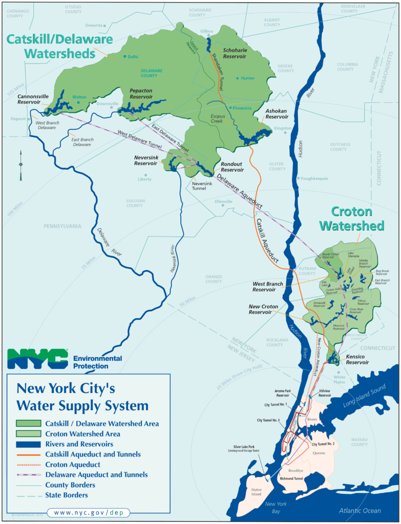
The New York City (NYC) water supply system is one of the largest surface water storage and supply systems in the world. In the United States, New York City is one of five metropolitan areas still supplying unfiltered surface water to its City residents.
The system reliably delivers more than 1.1 billion gallons of safe drinking water daily to nine million people – this represents nearly half the population of all New York State.
The NYC water supply system consists of three surface water sources:
- the Croton Watershed (375 square miles) east of the Hudson River
- the combined Catskill and Delaware watershed system (1,597 square miles) west of the Hudson River.
These watersheds combined drainage area
- totals 1,972 square miles (about 1.2 million acres)
- includes 19 reservoirs and three controlled lakes
Check out our program footprint map. Check to see if you are in the NYC Watershed here.
The Croton Watershed (East of Hudson)
- Is made up of the Croton and Kensico Watersheds
- Is located within parts of New York’s Westchester, Putnam and Dutchess counties and Fairfield County, CT.
- Was the original water supply for New York City.
- Is predominantly forested with horses, horticulture, livestock, hay and produce comprising the area’s agricultural industry, which is under intense development pressure
- Spans 375 square miles.
- Provides 10% of the City’s daily needs and up to 30% under drought conditions or for other operational demands.
- Will be filtered in the near future.
- Contains three controlled lakes:
- Kirk Lake
- Lake Gilead
- Lake Gleneida
- Contains 13 reservoirs
- Amawalk
- Bog Brook
- Boyds Corner (considered part of Delaware system)
- Cross River
- Croton Falls
- Diverting
- East Branch
- Kensico (considered part of Catskill system)
- Middle Branch
- Muscoot
- New Croton
- Titicus
- West Branch (considered part of Delaware system)
The Catskill/Delaware Watersheds (West of Hudson)
- Is located within Delaware, Greene, Schoharie, Sullivan, and Ulster counties.
- Is largely rural and comprised of small to mid-sized dairy, vegetable and mixed livestock farms.
- Is roughly 75% forested; 85% of those woodlands are privately owned.
- Spans 1,597 square miles.
- Provides 90% of the City’s daily water needs.
- Contains six reservoirs:
- Ashokan
- Cannonsville
- Neversink
- Pepacton
- Rondout
- Schoharie